

Geography of the project can be found on https://djv-com.net/web/public/map/auth/login. For easy viewing, use user = map, password = map. When you have access and choice of «OBJECTS» displays the list of objects in alphabetical order.
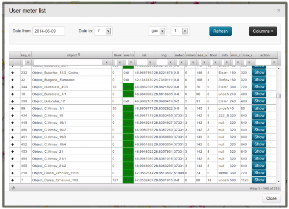
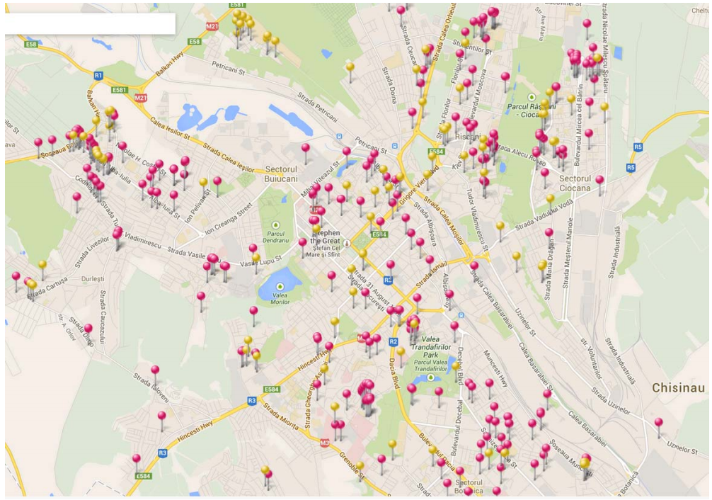
December 2014 at Moldova BALANCE system covered 326 of operating objects and 132 object in the project. On the same date, in Moldova in the balance sheet has more than 16 300 radio modules. Acting on the map objects are highlighted in pink, the objects in the design stage – yellow.
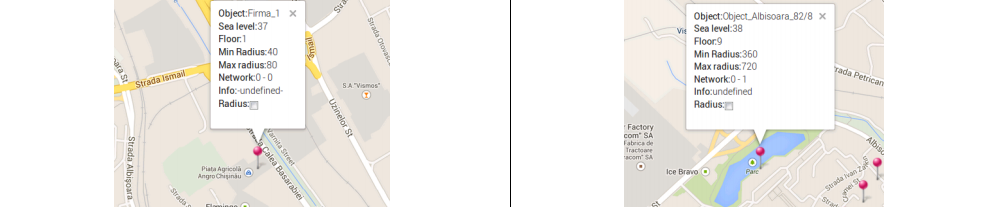
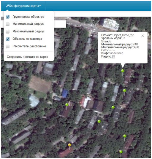 When you work with a map, except the mode switching map/satellite and language interface: English, Russian and Romanian, when you click on an object, displays the following information:
- The name of the object;
- The height of an object above sea level;
- Number of storeys;
- Minimum radius of coverage;
- Maximum radius of coverage;
- Information about a data network;
- Information about the object;
- Enable/disable the radius of the object.
In the tab “Configuration Card”, you can:
- Grouping of objects when you change the map scale;
- Activate Minimum radius of coverage;
- Activate Maximum radius of coverage;
- Coloring objects green with a common master – concentrator;
- Activate calculating the distance at map;
- Save current position on the map.
In the given example shows that when you select the “Dimo 22”, highlighted six five-story building, working on the same subnet, running the same master network – concentrator.
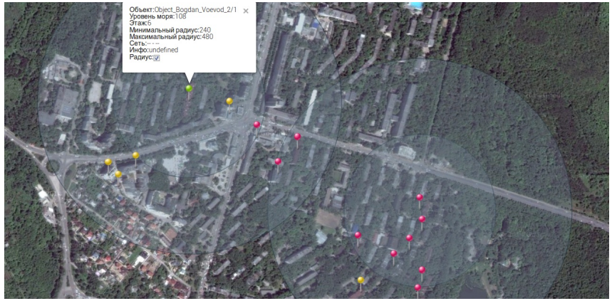
The “Radius” – allows you to include the minimum and maximum radius of coverage selected object or all objects at once. For designers radio it allows to evaluate the possibility of adding new objects in the system BALANCE in the existing infrastructure of data collection. The minimum radius shows that with high probability radio will be possible with the objects falling into it. At the same time, the area between the maximum and minimum radius allows for radio communication, but does not guarantee it. In this case, it is strongly recommended to use a different logical radio network for the prevention of conflicts and instability of the network.
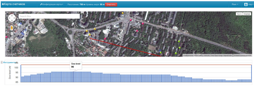
The “Calculate Distance” – allows you to calculate the distance between two selected objects, or two points on the map. If you select objects additionally takes into account their height. For designers of radio networks, this function allows to evaluate the possibility of adding new objects to BALANCE system into the existing infrastructure of data collection.
In addition to calculating the distance you get the profile of the earth’s surface between the selected objects or points on the map. This profile does not include the height of buildings and structures, and only the profile of the Earth’s surface above sea level.
Moving the mouse on schedule Profile Earth’s surface on the map will move a red flag indicating the point where you are.
This feature allows the system designer of BALANCE system, based on technology «D-Mesh» full use of existing data collection infrastructure to add new items.
Additionally, the added option “altitude” allows on the basis of hourly consumption profile of each subscriber and time profiles of atmospheric pressure in a given geographic location to calculate unadjusted difference in gas consumption and gas consumption adjusted in accordance with the current pressure at the time of consumption.
Firma_1 and Object_Albisoara_82 / 8 are located at a height of 37 and 38 meters above sea level,
Object_Cartus_93 and Object_Petrarilor_10/3 at a height of 223 and 210 meters above sea level,
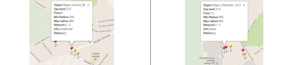
The difference in height of about 186 meters. When one percent error in pressure for every 80 meters, we find that the users are located in the lowland pay for gas by about 2.3% less than the users are located in the higher parts of the city of Chisinau.